 Ballista
How to Build a DOPE Card You Can Trust
Which columns a DOPE card needs, what step size costs if you read the nearest row, how far to print, and how far a card made at sea level goes wrong at 3,000, 6,000 and 9,000 feet of density altitude.
Print a DOPE card at sea level, drive to 6,000 feet, and it’s already a full 0.1 mil click wrong at 440 yards for a 6.5 Creedmoor and at 355 yards for a .308. At 1,000 yards the 6.5’s card is 0.78 mil off: 28 in high. The card wasn’t wrong when you printed it. It was right for one air. A card you can trust is one that says what air it was made for, has rows close enough together that you never guess between them, and stops where the solution stops being reliable.
The columns that earn their place
A DOPE card is read under time pressure, often in bad light. Every column has to be worth the space.
- Range. In the unit your rangefinder reads.
- Elevation in your turret’s unit, MIL or MOA, rounded to your click value. This is the column you use most.
- Clicks, if your turret is easier to count than to read, or if it’s in a different unit from the reticle.
- Wind for a fixed speed, usually 10 mph full value. You scale it in your head for the wind you call, as the wind drift article explains. A wind column computed for “today’s wind” is only right for today.
- Velocity or time of flight, optional. Velocity tells a hunter where the bullet still expands and where it nears the transonic zone. Time of flight is what you need to lead a moving target.
What usually doesn’t belong on a field card: drop in inches (you dial angles, not inches) and energy (unless a hunting minimum matters to you). They crowd the numbers you actually use.
Step size: what you lose between rows
Nobody interpolates carefully with a target in the scope. Under time pressure you read the nearest row. So the question is how much the come-up changes between rows.
| Step | Row-to-row change at 600 yd | Row-to-row change at 1,000 yd | Worst error, nearest row, 300–600 yd | Worst error, nearest row, 600–1,000 yd | Worst error, interpolating, 300–1,000 yd |
|---|---|---|---|---|---|
| 100 yd | 0.98 | 1.41 | 0.48 | 0.69 | 0.017 |
| 50 yd | 0.50 | 0.72 | 0.25 | 0.36 | 0.004 |
| 25 yd | 0.25 | 0.36 | 0.10 | 0.15 | 0.001 |
| 10 yd | 0.10 | 0.15 | 0.05 | 0.07 | 0.000 |
Two things jump out. Interpolating between rows costs almost nothing: even 100 yd steps are off by hundredths of a mil if you do the arithmetic. Reading the nearest row is not: with 100 yd steps a target at 950 yd can be 0.69 mil off, far more than a click. Halving the step halves the error. With 50 yd steps it’s up to 0.36 mil between 600 and 1,000 yd, and with 25 yd steps 0.15.
A practical rule follows: choose the step so that reading the nearest row costs no more than a click or two where you shoot. For this rifle that’s 50 yd inside about 300 yd and 25 yd beyond. If your rangefinder reads to a few yards and you want the card to keep up, a 10 yd step keeps the nearest-row error under a click everywhere on this card. If you’d rather print fewer rows, interpolate.
How far to print
Print as far as you’ll realistically shoot, and stop at the edge of what the solution can promise. That edge is the transonic zone. Below Mach 1.2 the drag curve gets steeper and harder to model, and small changes in air or velocity grow into bigger misses. In standard sea-level air the 6.5 drops below Mach 1.2 at about 1,140 yd and the .308 at about 790 yd. Rows past that point are still useful, but mark them so you know to expect wider dispersion and to confirm with live fire. The transonic article covers why.
When conditions need a second card
The card’s numbers depend on air density. Change the density and every row past a few hundred yards moves. We took the sea-level card and asked the engine what the rifle really needs in other air.
| Where you shoot | Density altitude, ft | 6.5: 1 click off from, yd | 6.5: off the plate from, yd | 6.5: card error at 1,000 yd, MIL | .308: 1 click off from, yd | .308: off the plate from, yd |
|---|---|---|---|---|---|---|
| Same place, 20°F | -2,700 | 660 | 850 | -0.31 | 525 | 720 |
| 3,000 ft, standard day | 3,000 | 580 | 785 | 0.42 | 465 | 665 |
| 6,000 ft, standard day | 6,000 | 440 | 655 | 0.78 | 355 | 560 |
| 9,000 ft, standard day | 9,000 | 375 | 590 | 1.09 | 305 | 505 |
Reading the table as a rule:
- A change of about 3,000 ft of density altitude moves the card a click by about 460 to 580 yd for these rifles. Inside that, one card covers you.
- Temperature alone is enough. A 20°F day at the same range is about 2,700 ft lower in density altitude than a 59°F day, and the 6.5’s card is off by a click from 660 yd.
- The lower-BC bullet needs a new card sooner. The .308 goes stale at shorter range in every case, and grows faster beyond.
So make a second card, or a column, whenever you’ll shoot past those ranges in air that differs by more than a couple of thousand feet of density altitude. One way to set this up: one card for the home range and one for each place you hunt or compete. Write the density altitude, temperature and date on every card. Without them you can’t tell which card you’re holding.
Powder temperature makes it worse. Many loads gain or lose velocity with temperature, and that error adds to the air’s. The temperature article separates the two.
Making the card in Ballista
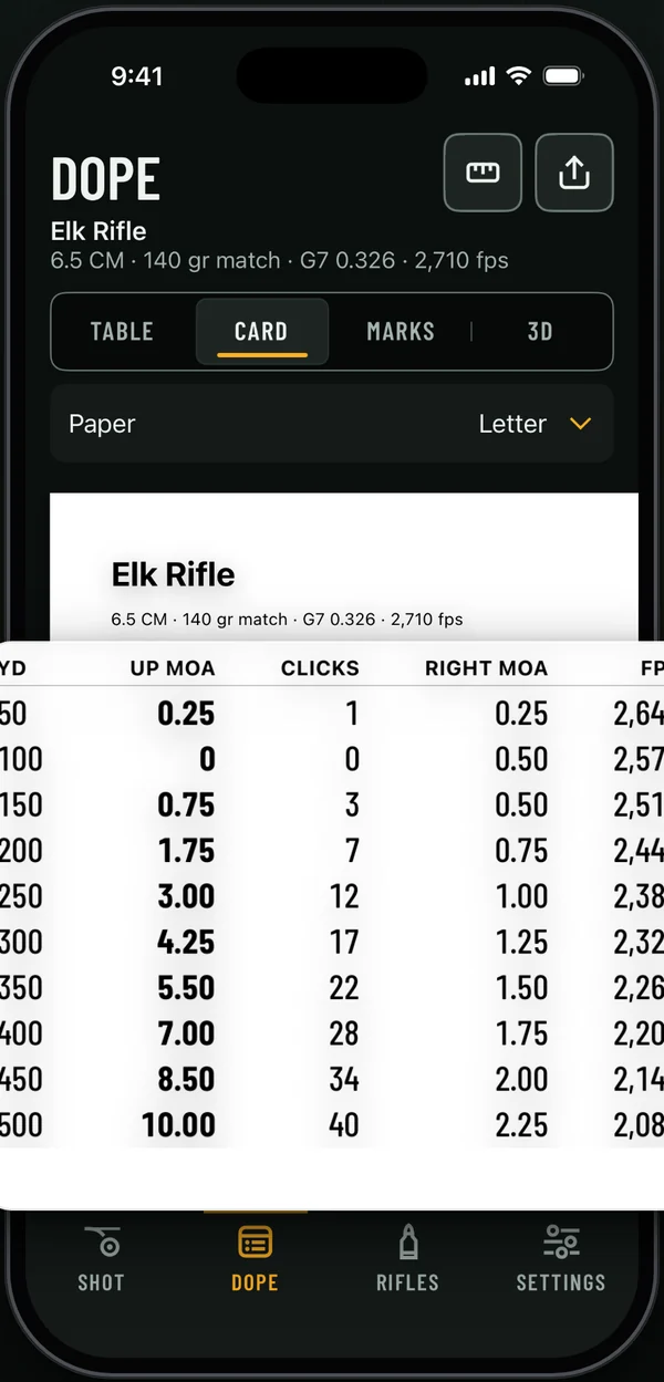
Ballista’s DOPE tab builds the table and the printable card from your rifle profile. Range and step set how far the card goes (To) and the row spacing, with steps of 10, 25, 50 or 100 yd. The table marks where the bullet drops below Mach 1.2 with a band reading “Transonic · less certain past here”. The Letter card prints range, elevation, clicks, wind, velocity, energy and time, and its footer records the zero air, today’s temperature, pressure and density altitude, and the date it was computed. Smaller papers include a 3×5 card and a Scope cap strip.
For a second card there’s a Places paper with an elevation column for today and for each saved place, each in its own air, and a Temperature chart with elevation at five air temperatures. After you print, if today’s air moves any printed row by a full click or more, the Card view shows “Your printed card is out of date” with the range and the number of clicks.
A card routine
- True the solution first: chronograph velocity and confirm drops at long range, as the truing article explains. A card made from a bad solution is neatly printed bad data.
- Columns: range, elevation in your turret unit, clicks if useful, a 10 mph wind hold. Velocity or time of flight if you hunt or shoot movers.
- Step: 50 yd to about 300, 25 yd beyond, or interpolate between wider rows. Reading the nearest row of a 100 yd card can cost more than half a mil.
- Print to the farthest range you’ll shoot, and mark where the bullet goes transonic.
- Label the card with density altitude, temperature, date and zero. Make another card when the air you’ll shoot in differs by more than about 2,000 to 3,000 ft of density altitude and you’ll shoot past 500 yd.
- Confirm the card with live fire at two distances before you rely on it.
Sources
- Bryan Litz, Applied Ballistics for Long-Range Shooting, 3rd ed., Applied Ballistics LLC, 2015. Atmospheric effects on trajectory and the transonic zone.
- ICAO standard atmosphere, used for the standard-day air at 0, 3,000, 6,000 and 9,000 ft.
- Every number in this article: Ballista engine (BallistaCore point-mass solver), inputs in the box above. See how we compute.